Open topic with navigation
Environmental & Risk Management / Compliance Management / Management Reports
Compliance Violations Map
The Compliance Violations Map report provides a comprehensive picture of violation status world-wide. The report provides a map view with both a drill-down list and Filter console to enable you to restrict the view to the locations you want to review. The map includes marker symbols over locations containing violations. These markers are color-coded to show areas by critical factors, such as violation severity, enabling you to quickly evaluate violations by location and to assess areas of concern.
You must enter a location for a violation to view the violation on this map. See Managing Compliance Violations.
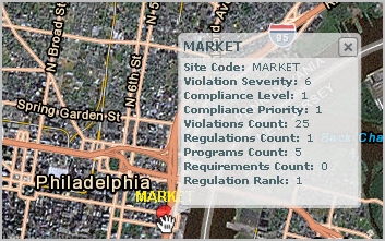
The map enables you to get more details in the following ways:
- When you click on a marker symbol, a pop-up window shows the violations used to summarize information for that location.
- When you mouse-over a map marker, a pop-up window identifies the location, the violation severity, , , Regulations Count, Compliance Programs Count, Requirements Count, and . The values for Level, Priority, and Rank are computed for the location depending on the selections for the marker symbol and filters you select.
About Marker Symbol Selections
Across the top of the map, there are selection lists that you can use to make the following selections for the marker symbols:
- Marker Size by
- Violation Count
- Violation Cost
- Marker Color by:
- + Severity
- Severity +
- Severity +
- Compliance Level + Priority
- Marker Color Method by:
- Average Value
- Highest Count
- Highest Risk _ Select the Minimum Threshold
- Lowest Risk - Select the Minimum Threshold
- Minimum Threshold: If you select Highest Value or Lowest Value for the Marker Color Method, then you also select the Minimum Threshold. This setting specifies the minimum percentage of the total violation count that a value must have before it can be considered the highest or lowest value.
- Location Level: This specifies the location level to highlight on the map. By default, the map show sites. The application uses the lat/lon of any location field for the location. Typically, this means using the lat/lon of any building level record in the Compliance Locations table, where the building’s lat/lon has been copied to the Compliance Locations record. For example, if “Country” is selected, then the application uses the lat/lon of any building in that country.