You can select multiple buildings through the drill-down selection list. Once you select the buildings and click Show Selected, each selected building is shown as a circle on the map.
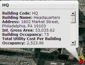
- Total Utility Cost per Building Occupancy
- Total Volume (CCF)
- Total Demand (kW)
- Total Consumption (MMBTU)
- Total Utility Cost
- Total Volume (CCF) per Building Area
- Total Demand (kW) per Building Area
- Total Consumption (MMBTU) per Building Area
- Total Utility Cost per Building Area
- Total Volume (CCF) per Building Occupancy
- Total Demand (kW) per Building Occupancy
- Total Consumption (MMBTU) per Building Occupancy